Toby Schwoerer, Zach Violett, Rob Whitney and myself headed up to the Eklutna (~900 feet elevation) to attempt a fast ascent of Bashful Peak. We used ~12 hours roundtrip (and would have gone under 12 hours if Rob hadn't collided on his mountain bike with an illegal motor bike on the return along the Eklutna lake. Compared to Bold peak, Bashful is a much more serious undertaking. It starts up the Stiver's gully like the Bold Peak climb, but right before you enter the Stiver's Gully proper you head right and out of the gully to a small and indestinct trail leading up through the alders towards Bashful. Once through the alders and across the moraines, we split into two teams to see which would be fastest. Rob and Zach went down a creek bed to access the Bashful ridge through a grass slope at about 3000 feet. Toby and I thought it would be faster to head straight up the side of Bashful with an idea to join the ridge at about 5500 feet. Boy, were we wrong. We ended up ascending horribly loose scree and near vertical Chugach crud while Zach and Rob were sitting and waiting (and laughing at us) on the ridge.

Rob and Zach hanging out at 5500 feet awaiting Toby and me struggling up the loose scree.
 The bottom of Chickenshit gully. Zach, our most experienzed rock climber, went up the gully and secured our rope to the horn at the top of the gully to help our ascent up the gully. The rope is not really necessary ... it almost makes it more dangerous as mit tends to knock loose rock and scree on the person climbing below.
 Bashful summit ridge above the Chickenshit gully.
 Chugach mountains to the East ...
 with a close up of Marcus Baker (the highest mnt in the Chugach at 13176 feet) where I had another sort of experience in April 2005 (see other post).
 Another Eastward view (with the North ridge of Baleful Peak coming into the picture at the right hand side). The prominent peak in the left foreground is Mt Hunter (7549 feet).
 Baleful Peak (the second highest peak in the Western Chugach (7990 feet). The "standard" route follows the left hand side (North) ridge line
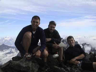
 The summit team: Rob, Toby and Zach, ...
 and the guy who carried the rope!
 Bashful summit ridge towards the top of the Chickenshit gully.
 Toby writing in the summit register.
 Zach rapelling the Chickenshit gully. On our way down we followed the ridge all the way back to ~3000 feet for an easy exit. Even though this involved regaining about 500 feet elevation to the moraine it was certainly the most pleasant way of getting off the mountain.
