Iztaccíhuatl (5230 m, 17,159 feet) and Pico de Orizaba (5636 m, 18,491 feet), Mexico, November 2009 with adventure companion Geir Ulstein, Nov. 4-14, 2009
With a few vacation days left in the bank and some travel lust left in my legs, Geir and I decided to meet in Mexico City for 10 days of trekking and sightseeing. As usual, Geir was using the opportunity to scout new trip possibilities for his adventure travel company (
EcoExpeditions). I think I am safe in saying that this trip itinerary will show up as one of his trip offerings very soon.
I was a little skeptical of Mexico City, having heard a lot of negative propaganda about the conditions in Mexico's capitol. The trip was a positive surprise from start to finish. The city was not all that polluted, traffic wasn't that bad, we never felt threatened, the weather was fabulous, and the food was great. A
nd Izta (Iztaccíhuatl) and Pico de Orizaba,the 8th and 3rd highest summits in north America, were more intersting (and challenging) than we had envisioned.

|
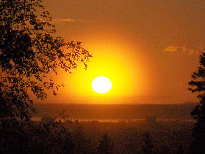
Panorama of Popo (Popocatepetl, 5410 m or 17,749 ft) in the sunris.
|

| 
|
Before embarking on the trekking part of the itinerary, we visited the pyramids at Teotihuacan. This picture shows the Temple of the Sun.
| From Teotihuacan, we went straight to the Popo-Itza National Park to prepare for the ascent of Izta. We stayed at the climbers refugio close to La Hoya. this picture shows sunrise from La Hoya towards Pico de Orizaba.
|

| 
|
Popocatepetl in the sunrise.
| Izta in the early morning. Iztaccíhuatl translates as White Woman or Sleeping Woman. Each part of the mountain are named after the woman's body parts; the feet (left in this picture), the knees (center of pic), belly, breast (summit) and head.
|

| 
|
Heading up towards Izta high camp on a day hike
| Lunch at Izta "high camp" (about 4700 m)
|

| 
|
Popo from Izta at daybreak. We started from La Hoya at 3 am and summited around 8 am.
| Popo from high on the first "Knee" on Izta
|

| 
|
Izta's shadow in the sunrise from high on the first "Knee"
| Summit ridge on Izta
|

| 
|
Popo from Izta's summit. Popo provided some incredible back-drops to an already beautiful climb.
| Guide Javier and Geir on the summit of Izta.
|

| 
|
Trond on Izta's summit.
| Izta's "glacier" between the summit (Izta's Breast) and Izta's Belly.
|

|
Heading back across Izta's belly.
|

|
Panorama of Popo from Izta summit
|

| 
|
Pico de Orizaba from the lowlands
| The fairly new Piedra Grande refugio on Orizaba. The refigio is at roughly 4200 m. From here the summit is a long 1400 m (4600 feet) away.
|

| 
|
On the first day at Orizaba we went for a day hike from the refugio up to the main high camp. This pic shows the moraine along trail below Orizaba.
| Lunch break in high camp (ca 4700 m) during acclimatization hike
|

| 
|
Foggy return from "high camp". We observed this weather pattern every day in the mountains here. Beautiful weather before noon, foggy and cloudy after noon.
| Early morning start for Orizaba summit day. We started at about 2 am and summited around 7:30 am. Compared to Izta, the climb up Orizaba was quite cold (-10 C, 14 F), and both Geir and I thought we would freeze our toes. Fortunately, no permanent damage was incurred.
|

| 
|
Sunrise high on Orizaba's snowfield. The climb is straight forward. Towards the top, the slope may approach 40 degrees, but the snow provided good crampooning.
| Orizaba's shadow stretching out towards Mexico City
|

| 
|
Javier and Geor on the crater rim
| Orizaba's crater. The crater is the deepest I have seen, must be 200-300 feet deep. Very impressive.
|

| 
|
Orizaba summit.
| Orizaba summit from the crater rim.
|

| 
|
Popo, Izta & La Malinche (4430 m, 14,534 ft, 24th highest in North America) from Orizaba
| Heading back down the upper Orizaba snowfield.
|

| 
|
Orizaba's "glacier".
| Heading down.
|

|
A last view of Orizaba.
|

|
Panorama from Orizaba summit. Sierra Negra (4580 m, 15,026 ft, 19th highest in North America) can be seen below to the left.
|

|
Panorama of Orizaba summit. Popo, Izta and La Malinche below to the right.
|

| 
|
Mexico City national theater.
| Zocalo, main cathedral in Mexico City.
|

| 
|
City-scape in Zona Rosa, Mexico City
| Photo exhibition along La Reforma, one ov the main avenues in Mexico City.
|

| 
|
Mexico's Independence statue.
| "Wall Street" - Mexico City's stock exchange.
|

|
The Wrestler. The anthropological museum in Mexico City is a fantastic collection
of artifacts. For anybody interested in Mexican history, this is a MUST.
|