Sunday, September 28, 2008

Mt. Maynard

Mt. Maynard, Chugach Mountains, Whittier.
September 28th, 2008
Highpoint: 4050 feet

On one of the best climbing days of the fall, I headed to Whittier to climb Mt Maynard. This is the prominent mountain that hosts the tunnel from Portage to Whittier. I accessed the mountain from the Whittier side, hiking up to Portage Pass and then up the Southeast face and up the South ridge to the summit. The trickiest part of this climb was the 60 degree slopes up the Southeast face (actually coming down was a lot worse than going up) and involved alder-belaying and down-climbing wet moss using the ice-ax for protection and brake. The summit ridge is very broken up (boulders with lots of hidden holes) but is not steep or technical. The summit provides glorious views in all directions.

View of Portage Galcier and Portage Lake from bench above Portage Pass.
View of Whittier and Passage Canal from about 2500 foot elevation on Mt Maynard.
Looking South across moonlandscape at about 3000 foot elevation on Mt. Maynard
Self-portrait with false summit of Mt Maynard in the background
Looking South along the summit ridge with the Kenai Mountains in the distance
The summit ridge was fairly narrow and snow-covered holes between boulders made it extra fun. The West face glacier with Portage Lake in the background
The final part of the summit ridge with the true summit being the far one.
Passage canal and Prince William Sound in the sunset.
Bard Peak (center) , Shakespare Shoulder (left) and the Whittier Glacier in the background.
Shakespare Shoulder (3517 feet) and Bard Peak (~3800 feet) are on my list for next year.
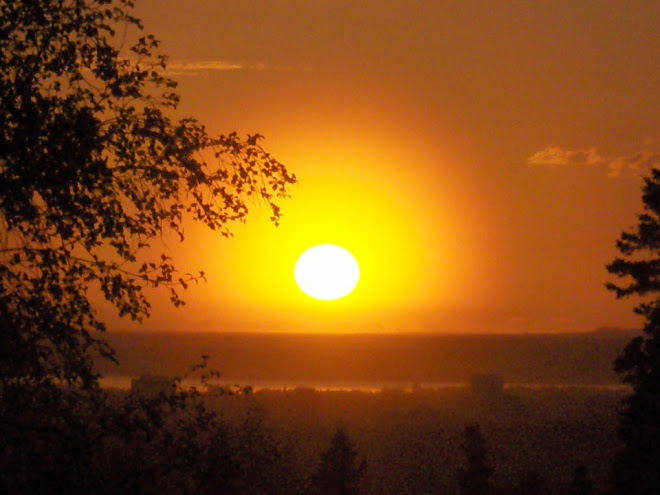
Looking North towards Learnard Mt (?) in the sunset.
This being late September, the days are getting much shorter. I failed to take that fully into account and ended up hiking out in the dark.
Northern panorama from the summit of Mt Maynard. Learnard glacier and Mt. Learnard make up the forground and the high Chugach mountains can be seen in the background.
Southern panorama from the summit of Mt Maynard. The Kenai mountains and the Harding Icefield are prominent in the center with the most prominent summit being Carpathian peak which sits at the head of the Portage glacier.

Saturday, September 20, 2008

East Twin

East Twin Attempt, Eklutna, Chugach Mnts, September 20th, 2008
Highpoint: ~5100 feet

East Twin has been on my list for a long time. But it has always had to take the back-seat to other peaks deeper in the Chugach. So I usually don't get around to it until it is too late in the year. The same happened this year, but I thought I would give it a go on September 20th anyway even though we already had snow down to ~4000 feet. WIth only trail running shoes and ski-poles I decided to turn around at ~5100 feet. But I gained valueable information about the peak and will have to come back later with ice ax and crampons or wait until summer. But it is definitely a worthwhile peak and from now on will be higher on my priority list.

Beautiful fall colors looking over Eklutna lake from about the 2000 foot level on the Twin Peaks trail.
Looking up towards East Twin (5873 feet) and the snowline at about 4000 feet)
Not much snow, just enough to make it interesting. Winter is definitely coming.
My route and highpoint on East Twin this day. One learning from this trip is that I need to drop into the main couloir lower on the mountain.
East (right) and West Twin peaks.
Fall colors below the Twin Peaks. Twin Peaks creek.
Parting shot of the Twin Peaks.
The Twin Peaks trail in fall shroud.


Sunday, September 14, 2008

Denali Road Trip

Denali Road Lottery, September 12-14, 2008
Cast: Claudia Rivera, Jose Salas, Thorsten Eiben, Susanne Kruse & Trond Jensen

Claudia and Jose had won a permit in the Denali Park Road Lottery and were kind enough to invite Thorsten, Susanne and me along for a weekend in Denali National Park. All the way up from Anchorage (and all the way back down) is was pouring down. But on the North side of the Alaska Range it was surprisingly nice fall weather, and we were treated to views of wildlife (brown bears, moose, caribou, Dall sheep, fox, etc), fall colors, the Alaska Range and Mt. McKinley.

Broad Pass already showing termination dust down to the 4000 foot level.
Thorsten and Susanne on our short friday hike up the Tripple Lakes trail.
Mount Brooks (11940 ft) in the Alaska range (neighbor to Mt. McKinley).
Mt. Brooks and the lower part of Mt. McKinley from Wonder Lake.
Another shot of the K2 look-alike Mt. Brooks. I'd like to climb this mountain some day.
A view of the Alaska Range over the McKinley River and the terminus of the Muldrow glacier.
Another shot across the McKinley river bar.
Denali - "the great one". The north summit is clearly visible in the middle of the photo while the slightly higher south summit is partially obscured by clouds.
Susanne and Thorsten on our Sunday hike up to Healy Pt.
Trond with Mt. Healy in the background.
Claudia and Jose bundled up in the windy and chilly September wind. Mt. Healy is the highpoint on the background horizon.
Fall colors looking NW into the Hines Creek drainage (start of Denali National Park).
Alaska range seen across the McKinley River bar from the Denali Park Highway. Mount Mather is seen on the left, Mt Brooks in the center and Mt. McKinley to the right.


Sunday, September 7, 2008

Vista Peak

Vista Peak, September 7th, 2008
Highpoint: 5070 feet

A rainy Sunday in September I decided to do some ridge hiking out of Eagle River (from Mt. Baldy trailhead). I was lucky with the weather as the rain held off for the entire 5 hours I was out. I made it to Vista Peak and may have continued to Peak 5331 if the weather had looked more promising. Peak 5331 will have to wait for another day. The ridges in this area are phenomenal for hiking and running. To top it off, the blueberries were ripe and the fall colors were awesome.

Panorama from Vista Peak looking SE to NW with Mt Magnificant on the left, then Blacktail Rocks Peak, Roundtop Peak, Pt. 4360, and the Peters Creek drainage on the right.
Vista Peak seen form the West.
Roundtop Peak from the SE.
Peak 5331 with Mt Significant behind.
A local family of Dall Sheep.
Another local.
Fall colors on Blacktail Rocks Peak.
Fall colors looking into Ptarmigan Valley with the Knik Arm in the background.

Saturday, September 6, 2008

Helihiking in the Talkeetnas

Helihiking in the Talkeetna Mountains North of Hatcher Pass
September 6th, 2008, with Kimball Forrest
Highpoint: Peak 5409

I am not one to turn down an opportunity to flightsee Alaska, so when Kimball called to see if I wanted to fly up North to go hiking I quickly cancelled all other plans for the day. Our orignial plan was to fly up to the headwaters of the Skwentna river where we had seen some beautiful terrain a week ago. But cloudy weather to the West made us change the flight plan to a more northerly route where the weather appeared to be much better. 45 minutes of flying found us searching for a flat spot to land on the tundra. From there we went hiking and scrambling for 3 hours on ridges overlooking the Kashwitna River drainage. We got back to the helicopter just in time as the flog was setting in. With a small opening in the fog we managed to escape and get back to Anchorage in due time.


Fall colors in the Talkeetna mountains north of Hather Pass.
Ridges and peaks perfect for hiking and scrambling.
The only local inhabitant we ran into.

Lots of large boulder fields to scamble across
One of Kimball's favorite hobbies ... rolling large boulders off of ridges.
The Talkeetna mountains. Beautiful ridge for running and hiking. Mostly the ridges are made up of scree and lichen, although some places require a little bit of scrambling. Kimball power hiking the scree slopes.

Pretty soon we found ourselves on a somewhat sketchy ridge with loose boulders and lots of potential for getting hurt.
One of the day's high points (~5200 ft elevation). We got cliffed out and I didn't want the pilot to get hurt so we decided we had seen enough. The summit on the left background is at about 5400 feet elevation.
Mt McKinley barely visible in the rising fog.
Perfect timing. When we got back to the helicopter, the fog was setting in. We quickly changed and headed out so that we wouldn't have to spend the night up there. An hour later we were drinking beer in Anchorage!