Markha Valley and Stok Kangri
Ladakh, Jammu & Kashmir, India, July 16-30th, 2009
Geir Ulstein and Trond Jensen
Geir and I flew to Leh in mid-July to do a bit of trekking, climbing (Stok Kangri, 6,137 m or 20,200 feet) and sightseeing. Leh is the capitol of
Ladakh which is part of Jammu and Kashmir in Northern India. Geir had planned it all as a scouting trip for his
EcoExpeditions adventure travel company and I was more than happy to support his efforts. Leh is situated in the rain-shadow of the Himalayas and has a desert climate. Flying in, we crossed snow and glacier covered peaks and landed in extremely arid Leh at ~10000 ft amongst brown hills.

Ladakh is called little Tibet and the entire area is very much influenced by buddhist culture, both past and present. In and around Leh there were temples, gompas and old fortresses from ages past.

Typical street in Leh.

Gompa and old fortress above Leh.

Leh city-scape. Not much room for new housing.

Leh with Stok Kangri in the background. Stok valley can be seen on the left side of the picture.

Shanti Stupa in Leh.

Thiksey Gompa south of Leh.

Munks calling for prayer at Thiksey Gompa.

Indus valley. The Indus river provides water for irrigation in and around Leh. If it hadn't been for the Indus, there would be no agriculture in the area.

Every temple and gompa has their own buddha statue, some very impressive. This one as 12 m (36 feet tall) and is gold plated.

Shey castle south of Leh.

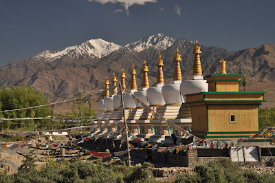
Stupas near one of Dalai Lama's summer houses.
Start of our Markha valley trek at Zingchan (11240 ft). The Markha Valley trek is usually done in about 8 days. Because of our compressed vacation schedule we decided to do the trek in 5 days by doing a few double-leg days.

Scenery between Rumbak and Yarutse before heading up to the Ganda La on the second day of the trek.

Geir approaching Ganda La (15960 ft).

A lone rose-bush in the otherwise very arid landscape.

One the way from Ganda La to Skyu (second camp) we descended an incredible deep and steep valley. With the sun beating down in the middle of the day, it must have been a 100 degrees. Combined with the altitude, the temperature and bright sun gave me a most intense headache.

The next morning we started out before 7 am to beat the heat of the day. The first few hours from Skyu to Markha were quite pleasant.

The hiking was mostly on good trails along valley bottoms, but once in a while, the river forced us up the valley sides on steep and intersting trails.

Inhabitation in the Markha valley. A few hundred people live in houses like this along the 50 mile long valley.

Mani wall and stupa along the Markha valley trail.

Markha gompa.

Markha valley agriculture. Mostly the valley was very arid, but a few places people make a living farming the land.

Old fortress in Markha valley.

Above Markha we had to make two river crossings, both short but somewhat challenging. On the second crossing, we learned to put the camera in a plastic bag in the backpack before crossing just in case.

Another mani wall along the trail. Just apile of rocks, right?

Actually, most of the "rocks" have intricate engraving of the Buddist prayer, Buddha sketches, or other Buddhist symbolism.

More "rocks" on the mani wall.

Another fortress overlooking the Markha trail. Nobody seemed to know the age of these old, abandoned fortresses or their history.

Trail above Markha on the way towards Nimaling.

High country trekking close to the Nimaling camp-site.

Nimaling camp-site (15620 feet) located on a wide plain below Kang Yatse (about 6400 m, 21650 feet), the highest peak in the Ladakh range.

After Nimaling we ascended Gongmaru La (16920 ft) and then headed down an amazing canyon to Chang Sumdo (12250 ft). From there we transferred by car to Stok Village.

Heading down the narrow canyon towards Chang Sumdo.

Geology above Chang Sumdo.

Heading up from Stok Village (11850 ft) to Stok Kangri basecamp (~16020 ft). Easy hiking and ascent all the way to basecamp.

We decided to skip high camp and make our summit attempt from a more comfortable basecamp. This would make for a longer summit day, but we felt good and well acclimatized. On July 25th we made an early morning start (3:30 am) for our summit attempt. We had already been up at 12:30 am but decided to go back to sleep for a couple of hours. The weather was unsettled and it had been raining and snowing on and off for the last couple of days. When we woke at 2:30 am, some stars were out and we decided to give it a try.

Heading up towards Stok glacier in the early morning.

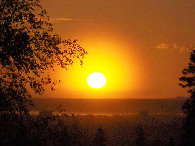
Sunrise.

Summit ridge of Stok Kangri. We had been climbing in the fog for most of the morning, but on the summit ridge we lucked out with some fine views toward the Northwest.

Stok Kangri summit ridge with a view towards Nun and Kun and the higher peaks of the Karakoram.

The Stok Kangri climb is generally very straight forward, but because of fresh snow and slick rocks we decided to rope up on the last couple hundred feet.

Stok Kangri summit at 9 am.

Stok Kangri viewed from the Stok glacier at sunrise.

After trekking and climbing we had signed up for a "jeep"tour from Leh to Manali. The trip took us over 3 very high passes, including TaglangLa (17882 feet) which is the second highest driveable pass in the world.

We were now heading south and into the monsoon rains. The roads were deteriorating. The Ladakh region is supplied by lorries (small trucks) carrying everything from clothing and food to gasoline. Driving south towards Manali along this only road connecting Leh to the south, it felt like we were swimming upstream against a continuous stream of lorries. It took 15 hours driving time from Leh to Manali. We stopped overnight in a small place outside of Keylong.

Lorry traffic. Uphill traffic always has the right-of-way on these roads.

Finally ... Manali (the Aspen of India). Ski-area and lots of hotels and tourist attractions.

One of the pleasures of this kind of trip is the local food and of course the abundance of fresh fruit.

The next day our flight to Delhi was cancelled due to monsoon storms, so we ended up spending another 15 hours in a car to get to Delhi and make our international connections. But it was all part of the great experience.
I highly recommend Leh and Ladakh to anybody who likes trekking, Buddhist culture and Indian food.
 At the outset, Mark proves to be a real tree hugger.


 Westward looking panorama from the summit of Gentoo. Left to rigth is Turnagain Arm, Penguin Ridge, Peak 4740, Bird Peak (pronounced summit pyramid in the ridght center of the picture, 5505 ft), California Peak (4974 ft), and Rubbletop Peak (4987 ft).


 Westward looking panorama from the summit of Gentoo. Left to rigth is Turnagain Arm, Penguin Ridge, Peak 4740, Bird Peak (pronounced summit pyramid in the ridght center of the picture, 5505 ft), California Peak (4974 ft), and Rubbletop Peak (4987 ft).