Nagoon Mountain (4403 ft) in the Berries Group, Chugach Mnts
Sunday, August 5th, 2012
19 miles, 5690 ft total vertical, 7 hours roundtrip
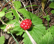
Sunday, August 5th, was another overcast weekend day (like most other weekend days this summer) with the cloud ceiling hovering around 3500 - 4000 ft. The weather looked a little better to the East so I decided to head out to the Berries. It had been a few years since I had been up the Berry Pass, so I thought I could at least go that far. And if the weather cooperated, I would try Nagoon Mountain, the northernmost mountain in the Berries. Most of the peaks in the Berries have berry names. Nagoon is the Tlingit name for arctic raspberry (http://en.wikipedia.org/wiki/Rubus_arcticus).
The route follows the Winner Creek trail from Girdwood up to the Berry Pass. This is the same route used by 20-mile River packrafters. From the pass, I headed up in a southeasterly direction until I gained the northeast ridge. I stayed with the northeast ridge all the way to the summit. This was a great ridge with the right mix of scrambling, exposure and route-finding, and some close-up wildlife encounter.
Nagoon Mnt left and Highbush Mnt (4669 ft) right seen from the Upper Winner Creek
View from Berry Pass looking North. Kelly's Knob (2858 ft) in the right foreground and Longspur Peak (5401 ft) in the center.
From the summit ridge looking Northeast. 20-Mile river in the foreground, 20-mile glacier in the background.
Half-way up the summit ridge I ran into a flock of Mountain Goats.
Sitting quietly, I had a whole flock pass me at no more than 12 feet. We had a staring contest for about 5 minutes.
Only once they had continued on their way dared I get up and continue on my merry way.
Summit pyramid of Nagoon Mnt.
Self-portrait from the Nagoon summit with Kinnikinnick Mnt (4468 ft) in the background.
View from the summit overlooking the 20-mile glacier, Kinnikinnick Mnt and some of the central Chugach mountains.
South view from the summit with (left-to-right) Blueberry Hill (4531 ft), Lowbush Mnt (4229 ft), Highbush Mnt (4669 ft), Lingon Mnt (4098 ft), and Berg Peak (3917 ft).
Southern panorama from Nagoon Mnt summit with (left-to-right): 20-Mile Glacier, Kinnikkinnick Mnt (4468 ft), Blueberry Hill (4531 ft), Lowbush Mnt (4229 ft), Highbush Mnt (4669 ft), Lingon Mnt (4098 ft), Berg Peak (3917 ft) and True Summit (4423 ft). Right of True Summit is Mnt Alyeska (not a true summit).


No comments:
Post a Comment